How Geography Made The US Ridiculously OP — @RealLifeLore
@RealLifeLore Infographic Summary
Table of Contents
- The US Empire’s Global Influence | 0:00:00-0:00:20
- The Economic Value of Navigable Rivers and the Mississippi River | 0:00:20-0:06:20
- Agriculture, Transportation, and Protection of the US Gulf and East Coasts | 0:06:20-0:10:20
- Natural Harbors in North America | 0:10:20-0:12:50
- Significance of the Mississippi River in US History and Geography | 0:12:50-0:19:00
- The Geography of North America: Impact on Agriculture and Economy | 0:19:00-0:23:00
- Technological Advancements in Drilling: Revolutionizing the Oil and Gas Industry | 0:23:00-0:31:20
- The Role of Trade and Military Interventions in Shaping US Foreign Policy | 0:31:20-0:34:00
https://youtu.be/BubAF7KSs64
The US Empire’s Global Influence | 0:00:00-0:00:40
The US empire is known for its ability to enforce its will across the planet. Despite not being the largest, in terms of territory., it has a significant economic impact and dominance, globally.
The Economic Value of Navigable Rivers and the Mississippi River | 0:00:40-0:06:40
The United States has been the world’s largest economy since the 1890s, with a strong economy and military power. The US dollar is the primary reserve currency globally. The geography of North America, particularly the Mississippi River, has played a significant role in America’s rise to power. The river’s navigability and strategic location have facilitated trade and expansion, contributing to America’s dominance as a global superpower.
The Mississippi River, along with rivers like the Rhine, are valuable for generating economic activity due to their cost-effective transportation capabilities compared to land-based infrastructure. Rivers are cheaper to use for transporting goods and people as they require less initial and ongoing maintenance costs. Navigable rivers contribute to higher profits for civilizations by reducing transportation expenses significantly in the modern era.
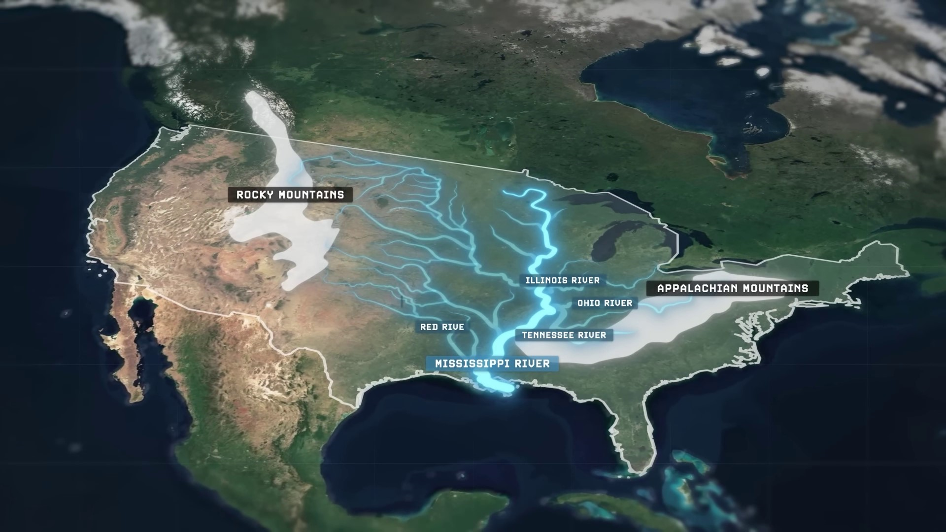
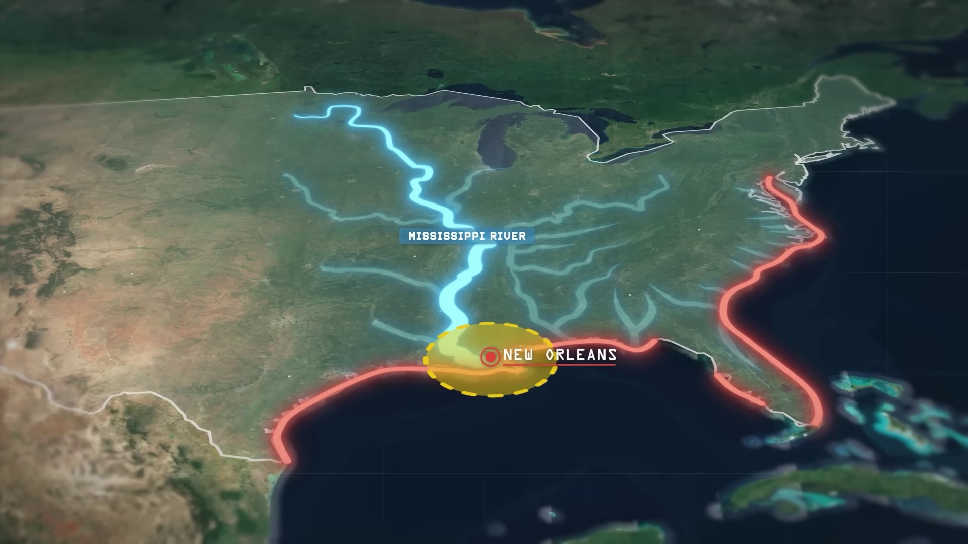
This fact instantly makes the Mississippi River as the longest navigable river in the world tremendously The Delta is tremendously economically valuable to anybody who controls it. Farms and factories built along or nearby the 3,000 kilometers of its banks between the Delta and the Gulf of Mexico and the waterfalls at Minneapolis-St. Paul are capable of cheaply exporting their products further downstream and out into the world ocean toward global markets, markets. But the Mississippi River itself is only the main stem of the overall greater network of navigable rivers found across the greater Mississippi Basin, granting settlements as deep into the interior of North America as Pittsburgh, Cincinnati, Minneapolis, Chicago, Sioux City, St. Louis, Memphis, Skokie, Shreveport, and more to effectively become oceanic ports, all capable of exporting their various products cheaply down the Mississippi River network towards the Gulf of Mexico. But it isn’t just this uniquely vast system of internally navigable rivers, within North America that give this continent such an advantage to commerce. It’s also the fact that around much of North America exists another, highly unique geographic feature that cannot be found anywhere else in anywhere near such a useful pattern. The many, many barrier islands that exist in an almost continuously uninterrupted chain for more than 4,800 kilometers.
Agriculture, Transportation, and Protection of the US Gulf and East Coasts | 0:06:40-0:10:40
The US Gulf and East Coasts are protected by low and flat islands, spanning from the southernmost tip of Texas to the Chesapeake Bay. These islands create a network of shielded bays that serve as a natural barrier along the 4,800-kilometer coastline, resembling an oceanic river, which are relatively navigable all the way from Brownsville, Texas, to Baltimore, Maryland. And since the delta of the Mississippi River empties out directly into this further navigable network, it means that goods have been able to be cheaply, reliably, and quickly transported from all throughout the North American interior to all across the Gulf and East Coast now for hundreds of years, years.
When collectively added together, the internal rivers of the Mississippi Basin and this external, intracoastal waterway wrapping around the Gulf and East Coasts account for nearly 25,000 kilometers of combined navigable waterways, which is not only more than the rest of North combined, but more than the rest of the entire planet combined. The end result is the greatest natural transportation system to be found anywhere in the world. An enormous network of freely available riverine superhighways that causes 90% of the lower continental 48 United United States to be within just 240 kilometers of an easily navigable waterway.

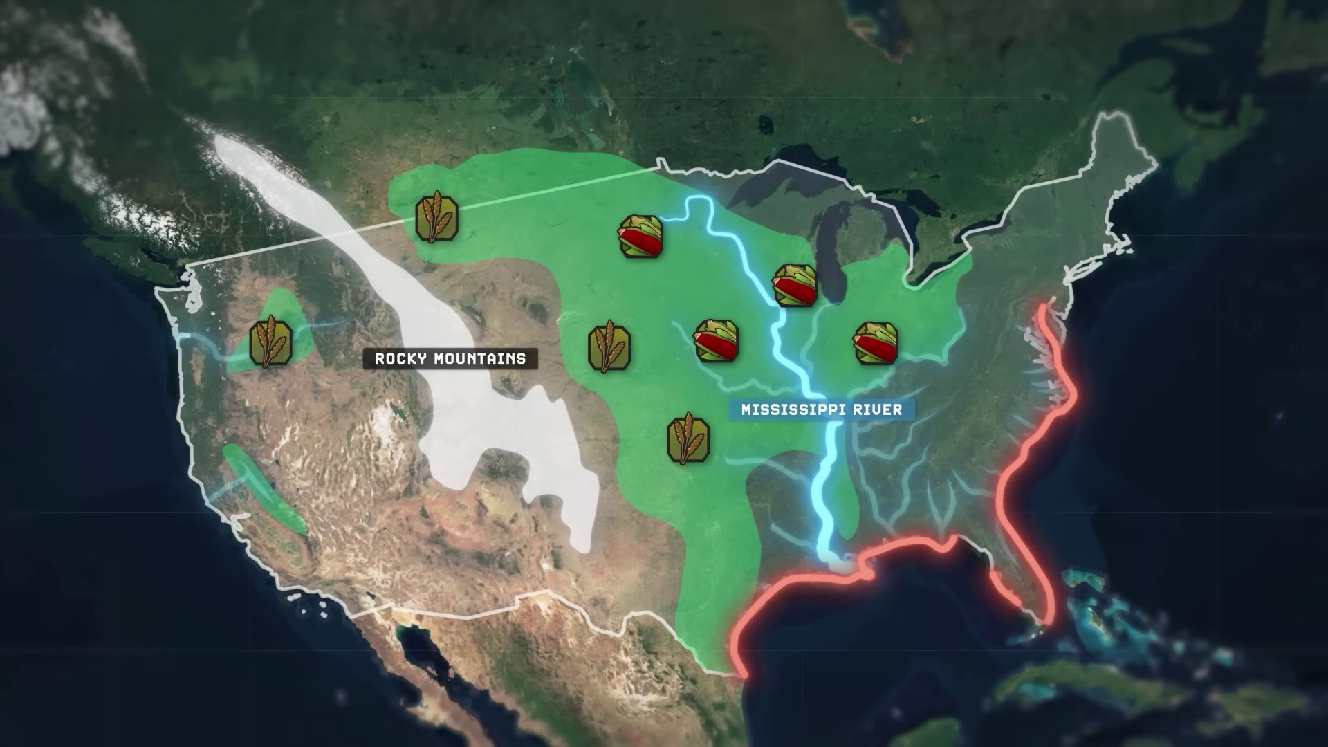
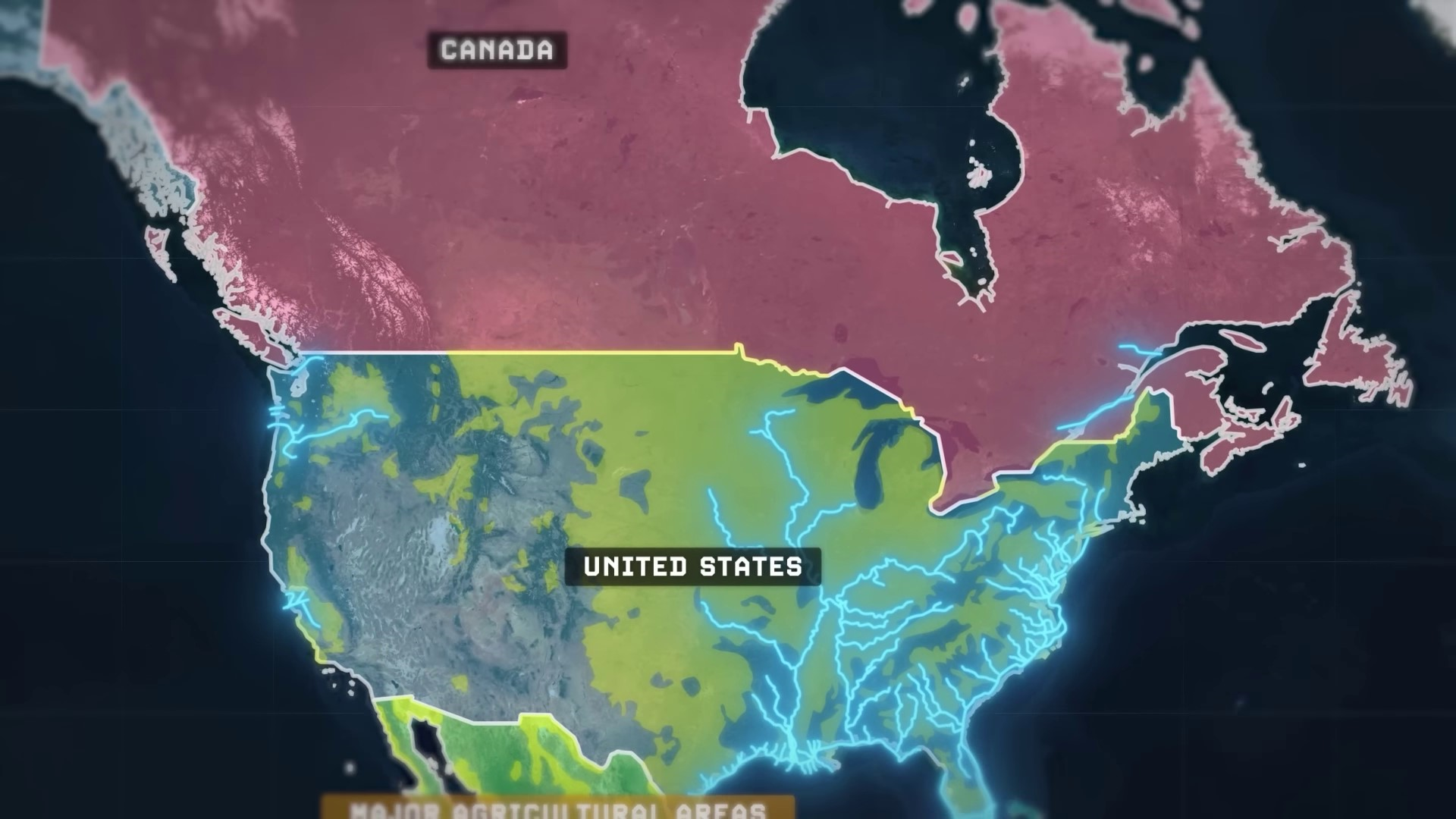
And it was all just effectively given to the United States more than two centuries ago, back in 1803 when the French decided to sell all of it for about $340 million in today’s currency And then, the power that this system of natural navigation offers the United States is even further exacerbated when you consider that it spans across what also just so happens to be the largest contiguous stretch of arable farmland on the planet as well. The westernmost portion of the Midwest, located within the rain shadow cast by the towering Rocky Mountains of the continent, is dry but temperate and perfect for growing wheat like Ukraine and southern Russia, while the central portion is temperate and humid, perfect for growing corn and soybeans. Today, an area more than twice the size of France is under till within the Midwest alone. And as a result, this region produces nearly a third of the entire planet’s supply of corn and soybeans.
North America’s agricultural land overlaps with the world’s largest network of navigable rivers, facilitating easy transportation of agricultural produce. The continent’s geographic advantages, including rivers like the Columbia, Snake, San Francisco Bay, and Sacramento River, enable efficient transportation of food from rural areas to urban centers. This unique advantage positions North America as an agricultural superpower with significant potential for maritime power and commerce.
Natural Harbors in North America | 0:10:40-0:13:20
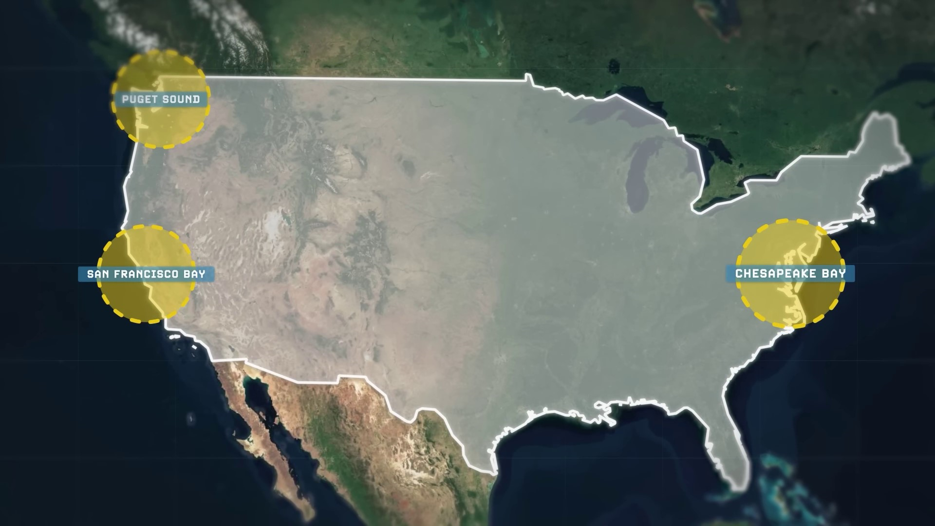
Natural harbors in the US are essential for creating good ports, which have deep passages for shipping, resources in the hinterland, and ample coastal frontage. The top three largest natural harbors with these factors are in North America and controlled by the United States: Chesapeake Bay, San Francisco Bay, and Puget Sound. These harbors are among the most impressive globally, with Chesapeake Bay standing out on its own.
The United States has a coastline longer than India’s and over three and a half times the length of the entire African continent. Despite Africa being larger in land area, the US coastline offers significant port potential. Additionally, the US gained a second navigable waterway in the mid-20th century through civil engineering.
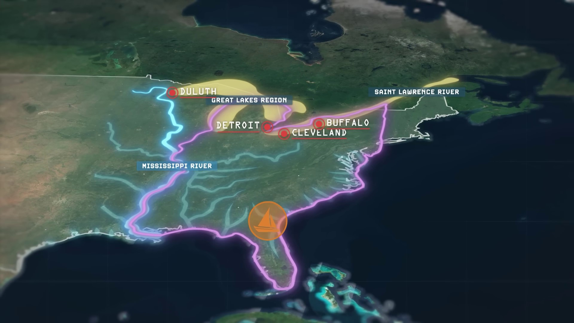
The Great Lakes were not naturally navigable until the late 1950s when locks and canals were built. They now serve as an internal water transportation system connecting cities like Duluth, Detroit, Cleveland, and Buffalo.
Significance of the Mississippi River in US History and Geography | 0:13:20-0:19:20
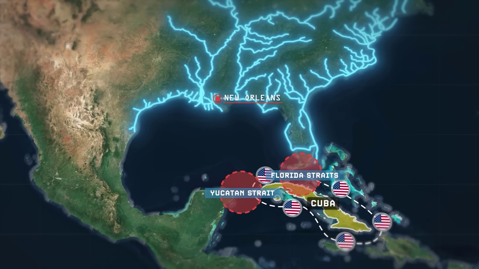
The Mississippi Basin and Great Lakes System are connected through artificial canals, allowing barges to navigate around the eastern United States. New Orleans is strategically important as the gateway between the Mississippi River network and the Gulf of Mexico. Its fall could disrupt the entire transportation system. Cuba’s strategic position in the Gulf of Mexico poses a potential threat to American trade routes, leading to a long-standing trade embargo by the US against Cuba.
The Mississippi River has been a significant factor in shaping the history and geography of the United States. It has been a challenge for foreign powers to establish themselves in the region due to the country’s efforts to control its people and prevent foreign dominance. The river’s constant meandering and desire to change its course have been ongoing for thousands of years, presenting a unique challenge for those living along its banks.
The Mississippi River’s delta has shifted across the Louisiana Gulf Coast, posing a potential threat to infrastructure and water sources in Baton Rouge and New Orleans. The United States Army Corps of Engineers constructed the Old River Control Structure in Vidalia to prevent this shift. The geographical advantages of the United States, including its strategic location and lack of regional rivals, have contributed to its development as a maritime empire. Mexico’s geography, with mountainous lands and limited navigable rivers, contrasts with the favorable conditions in the United States.
The Geography of North America: Impact on Agriculture and Economy | 0:19:20-0:23:20
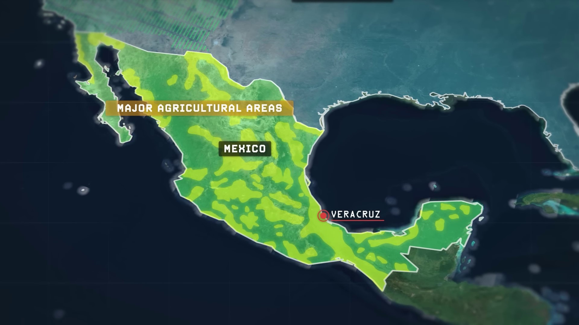
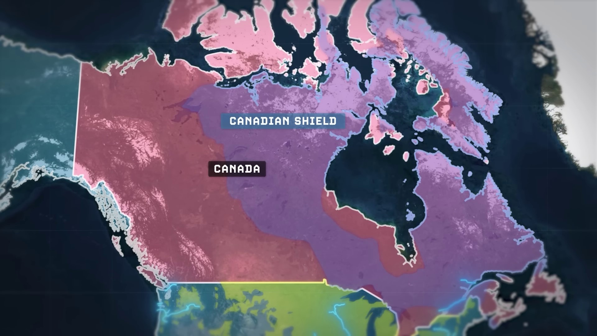
The geography of North America, particularly in Mexico and Canada, plays a significant role in shaping the agricultural and economic landscapes of the countries. Mexico’s agricultural areas are isolated within valleys among mountains, while Canada’s Canadian Shield region lacks usable soil for agriculture, separating the productive core around Toronto and Montreal from the Prairie Provinces and British Columbia. The limited internal navigable rivers in Canada lead to economic integration with the United States to the south. The geographical barriers, including oceans, make the core region of North America highly secure and difficult to invade, contributing to America’s geopolitical strength. The United States also controls a significant portion of the world’s naval tonnage and dominates the world’s oceans, making it challenging for foreign powers to overcome.
Technological Advancements in Drilling: Revolutionizing the Oil and Gas Industry | 0:23:20-0:31:40
In the 1970s, the US faced vulnerability due to over-dependence on foreign oil, leading to oil embargoes and price spikes. The country’s energy supply was affected by events like the Yom Kippur War and the Iranian Revolution. By 2005, America was importing 60% of its oil supply due to domestic production limitations. However, technological advancements in drilling, specifically fracking, revolutionized the oil and gas industry in the early 21st century. Shale rock in Texas, particularly in regions like the Barnett and Permian Basin, revealed massive oil and gas reserves, making Texas a key player in the global energy market.
In the past decade, Texas and other regions in the United States have experienced a significant boom in oil and gas production, leading to Texas becoming a major oil producer surpassing many OPEC countries. The discovery of vast oil and gas fields, including the Marcellus Field, has tripled the estimated natural gas reserves of the United States. The U.S. has also become the second largest exporter of natural gas and regained its title as the world’s number one producer of oil, surpassing Saudi Arabia and Russia.
The United States has achieved energy independence through its vast shale basins located within the interior of the continent. It no longer relies on outside sources for energy supply, with Canada and Mexico providing around 60% of imported oil. Despite this independence, the US maintains a heavy presence in the Middle East due to the region’s importance to the global economy and US allies in East Asia. The interconnected web of trade with the rest of the world, particularly the Middle East, plays a significant role in the US economy. The US swiftly intervened in 1991 to prevent Saddam Hussein from controlling a large portion of the world’s oil supply. This led to the Gulf War and subsequent US military presence in the region. The aftermath of these events, including the War on Terror and the invasion of Afghanistan, shaped American foreign policy for the next two decades. The United States withdrew from Afghanistan in August 2021, leading to a Taliban resurgence and highlighting the limitations of even the most powerful empire. The war in Afghanistan, spanning a significant portion of American history, is crucial to understand for Americans.
The Role of Trade and Military Interventions in Shaping US Foreign Policy | 0:31:40-
The interconnected web of trade with the rest of the world, particularly the Middle East, plays a significant role in the US economy. The US swiftly intervened in 1991 to prevent Saddam Hussein from controlling a large portion of the world's oil supply. This led to the Gulf War and subsequent US military presence in the region. The aftermath of these events, including the War on Terror and the invasion of Afghanistan, shaped American foreign policy for the next two decades. The United States withdrew from Afghanistan in August 2021, leading to a Taliban resurgence and highlighting the limitations of even the most powerful empire. The war in Afghanistan, spanning a significant portion of American history, is crucial to understand for both Americans and Afghans.